In a global context marked by accelerated ecosystem degradation and the collapse of freshwater sources, restoring native forests stands out as one of the most powerful—yet underused—strategies to rebalance the hydrological cycle, reverse biodiversity loss, and increase climate resilience. The upper San Juan River basin, located in Colombia’s Western Andes, holds one of the last continuous remnants of montane cloud forest in the country and is home to numerous endemic and threatened species. However, this region has suffered a drastic reduction in forest cover, severely impacting infiltration, water quality, and ecological connectivity.
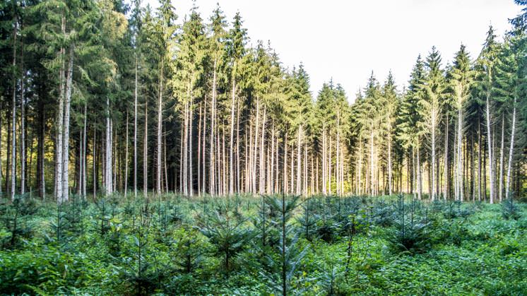
In response to this challenge, the Reforestation Project at the Mesenia-Paramillo Nature Reserve offers a concrete and transformative solution: the active restoration of 556 hectares of high Andean cloud forest through native species planting, rehabilitation of degraded areas, and implementation of ecological and hydrological monitoring systems. This intervention not only captures carbon and regenerates critical habitats, but also enhances soil infiltration on steep slopes, reduces surface runoff, and improves water regulation at the watershed level.
Using methodologies A-1 (Curve Number Method) and A-4 (Recharge Method) from the VWBA 2.0 framework, this project quantifies the Volumetric Water Benefit (VWB) generated by forest restoration and its effects on the regional water balance. It is estimated that the intervention will help recover between 30 and 40 million liters per year, a volume equivalent to the annual consumption of approximately 1,000 people in rural Colombia. This figure not only reveals the potential of the approach, but also highlights the urgency of scaling it nationally and internationally.
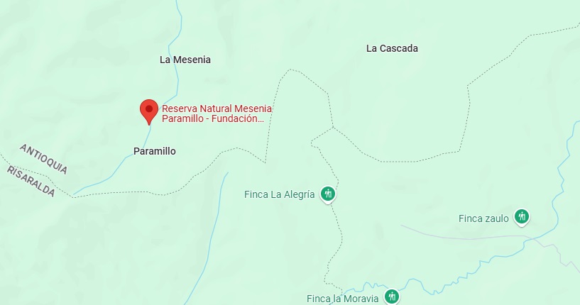
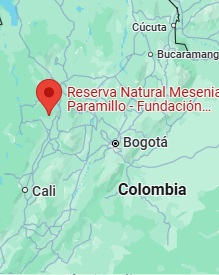
Located between the departments of Antioquia and Risaralda, this project has been structured by Aqua Positive in partnership with the Colibrí del Sol Foundation (which manages the reserve), with technical support from the VWBA team. The implementation adheres to strict principles of additionality (by targeting previously unprotected or degraded areas), traceability (using sensors, drones, and annual reports), and intentionality (as part of a clear Water Positive strategy).
In a world where every restored hectare counts, this initiative proves that forests do more than capture carbon—they also capture hope, infiltrate the future, and produce water. Now is the time to reforest with strategic vision.
This project was born in response to a critical environmental pressure: the progressive loss of forest cover in key recharge zones due to extensive cattle grazing, illicit crop cultivation, and informal deforestation. This degradation has reduced soil infiltration capacity, increased runoff, and eroded the baseflows of creeks that supply water to rural communities and high-mountain ecosystems. Moreover, the absence of native vegetation has weakened the region’s resilience to extreme weather events such as prolonged droughts and torrential rains.
In light of this, the Colibrí del Sol Foundation, in collaboration with Aqua Positive, has designed a replicable, measurable solution aligned with VWBA principles: reforestation with native species adapted to cloud forest conditions, combined with active ecological restoration practices and digital hydrological monitoring. The project is implemented in plots previously affected by grazing or deforestation, ensuring the additionality of every cubic meter generated.
The expected impact is threefold: in the short term, increased vegetation cover and improved local infiltration; in the medium term, recovery of baseflows in strategic creeks; and in the long term, increased aquifer recharge and ecosystem resilience. Overall, the project is expected to recover 30 to 40 million liters of water annually, with potential to scale this figure by doubling the area restored.
This restoration model is ideal for companies looking to offset their water footprint in priority basins, generate verifiable VWBA credits, or strengthen their sustainability narrative with tangible impact. By investing in this project, companies in sectors such as beverages, mining, energy, or tourism can meet their ESG targets, demonstrate climate leadership, and join a global community that is transforming landscapes and futures.
In a world that urgently needs more nature-based solutions, this project proves that reforestation is no longer a romantic idea—it is a strategic tool for measurable water replenishment, validated, scalable, and deeply transformative.
Ecological restoration of 556 hectares with native species selected for their edaphic adaptability and functional importance in moisture retention, carbon fixation, and structural litter generation that improves soil infiltrability.
Maintenance and active protection of strategic groundwater recharge areas, prioritizing zones with moderate slopes, highly porous andic soils, and potential canopy cover with closed-canopy species that reduce direct evaporation and promote deep percolation.
Progressive removal of livestock pressure through fencing, community exclusion agreements, and revegetation with native grasses along edges to prevent trampling, compaction, and loss of soil structure.
Multiscale hydrological monitoring using optical and radar remote sensing, LIDAR sensors, and periodic drone flights with multispectral cameras to validate biomass recovery, canopy density, soil cover, and changes in surface moisture indices.
Active participation of local communities in nurseries, planting, and monitoring, integrating participatory science methodologies and social validation of the ecological process, with technical training in forestry management, digital cartography, and hydro-meteorological parameters.
The implementation process is organized into three operational phases, each with technical components, a detailed timeline, and specific deliverables:
Phase 1: Preparation, Planning, and Community Strengthening (Jan 2026 – Dec 2027)
This phase establishes the project’s technical and social foundations. A biophysical and socio-environmental characterization is conducted using multispectral remote sensing (Sentinel-2, PlanetScope) to map cover, slope, and surface moisture, alongside soil sampling (structure, field capacity, saturated infiltration) and field validation via drones. Restoration Units (URs) of 5–20 hectares are defined based on altitudinal gradient, soil type, ecological connectivity, and recharge importance.
Propagation nurseries are designed with germination and hardening modules capable of producing over 400,000 seedlings per year, incorporating automated misting technologies, closed composting systems, and traceability via QR-coded batches. Seeds are collected from 42 prioritized native species selected for their root architecture, drought resistance, and ecological value. 140 individuals are trained in silviculture, bioengineering, traceability, plant health protocols, and agreements are signed with environmental authorities (CVC, Corantioquia) to ensure regulatory compatibility.
Phase 2: Active Ecological Restoration, Regeneration, and Baseline Monitoring (Jan 2028 – Dec 2030)
This phase focuses on technical execution. 1,008,000 trees are planted with adaptive densities (800 to 2,000 plants/ha) depending on target cover type (mature forest, riparian, transitional). Planting techniques include contour lines, live barriers, infiltration terraces, and vegetated microcatchments with facilitative species (Inga sp., Heliocarpus sp.) that reduce runoff and increase effective infiltration.
Twelve automatic hydro-meteorological monitoring stations (precipitation, temperature, ET), eight capacitive soil moisture sensors (up to 60 cm depth), three limnimetric stations in streams, and two weighing lysimeters are installed to directly measure net percolation in restored plots. These lysimeters record effective infiltration in mm/day, correlated with rainfall events, cover type, and local slope. In parallel, the double-ring infiltrometer method is used to estimate point infiltration rates (preliminary data range: 65–120 mm/h), which help establish infiltration coefficients by cover type and restoration year.
Data are integrated into a geo-statistical database that feeds distributed hydrological models (e.g., SWAT or HEC-HMS), allowing estimation of increased groundwater recharge through adjusted water balances. The model accounts for potential evaporation, interception, direct runoff, and changes in soil storage to derive m³/year of water entering the restored aquifers. This value supports the calculation of Volumetric Water Benefits (VWBs) under VWBA Appendix A-4.
Water quality indicators (turbidity, conductivity, dissolved oxygen) are also monitored using field kits and portable spectrophotometry at five sampling points. The entire system is managed via a monitoring dashboard hosted on local servers and backed up in the cloud.
Phase 3: Impact Consolidation, Verification, Water Governance, and Scalability (Jan 2031 – Dec 2033)
In this phase, results are consolidated and verifiable products are generated. An external third-party audit is conducted to validate reported VWBs, annual net benefits (in m³) are calculated, and a technical report is produced to support claims under the VWBA 2.0 framework. Comparative scenarios with baseline conditions are evaluated, and cumulative impact curves are developed.
A local Payment for Ecosystem Services (PES) mechanism is structured, defined based on avoided sediment load and improved effective recharge. The model is documented for replication in other reserves, including operational manuals, monitoring protocols, unit activity costs, and water benefit projections.
A water governance component is developed based on agreements with community action boards, rural aqueduct associations, and institutional actors. In addition, training is coordinated in rural schools and technical education modules with content on restoration and water accounting.
Each phase is backed by verifiable deliverables: databases, georeferenced maps, technical reports, interinstitutional contracts, training materials, and impact reports. Altogether, the Mesenia-Paramillo project constitutes a technical and social benchmark in restoration based on measurable, auditable water benefits, aligned with global commitments such as the SDGs, Science-Based Targets for Water, and the European ESRS E3 standard.
The Mesenia-Paramillo Nature Reserve, located in the Western Andes of Colombia, represents one of the most emblematic ecological restoration efforts in critical water recharge areas in Latin America. The project emerges as a direct response to deforestation, erosion, and loss of ecosystem services that have degraded the humid montane forests of the region, particularly in the San Juan River basin, a strategic tributary of the Cauca River.
The main objective is to restore 556 hectares of forest through active reforestation with selected native species and assisted natural regeneration to improve hydrological flows, increase aquifer recharge, reduce surface runoff, and recover the ecosystem’s ecological functionality. These impacts are to be quantified under the Volumetric Water Benefit Accounting (VWBA 2.0) framework.
The process is structured in multiple phases. It begins with an assessment of ecological and hydrological degradation in the area, identifying the most vulnerable intervention zones through satellite analysis, soil studies, and land cover characterization. Community nurseries are then developed to produce key species such as Quercus humboldtii and Clusia multiflora. Restoration follows, integrating planting on contour lines, livestock exclusion, and the establishment of ecological corridors. Each action aims to maximize water infiltration, stabilize soils, and reactivate natural biogeochemical processes.
In parallel, a multiscale monitoring platform is deployed, including LIDAR sensors, Sentinel-2 imagery, and drones with multispectral cameras, complemented by water quality and soil moisture measurement stations. These data allow real-time estimation of hydrological indicators such as ET, NDVI, NDWI, and base flow, facilitating the traceability and external validation of generated VWBs. Community participation is key: more than 120 local people have been trained as parascientists to implement and oversee the process, ensuring sustainability and social ownership.
In addition, the project is integrated into global initiatives such as Water Positive and reported under frameworks such as ESRS E3 and Science-Based Targets for Water.
This restoration not only improves the regional water balance but also strengthens climate resilience, ecological connectivity, and sustainable development for surrounding communities.
In summary, Mesenia-Paramillo is a replicable model of ecological restoration with validated water benefit, integrating science, technology, and environmental justice in a high-priority context for the country’s water security and global sustainability commitments.