In a world where disasters no longer surprise but repeat with growing intensity, inaction means accepting loss. Every year, thousands of communities across Latin America watch as rainfall turns into devastation, rivers into threats, and dawns into desperate evacuations. In mountainous basins, a flash flood can shift from a subtle rise to a deadly torrent in under 20 minutes. This urgency demands solutions that combine technology, community response, and systemic foresight. This project is not just a response—it is a transformation in how we relate to water and risk.
The Community-Based Early Warning System (EWS) is designed to anticipate river flooding through water-level sensors in mountain streams, signal transmitters, automatic alarm sirens, a digital visualization platform, and local evacuation protocols. Beyond saving lives, it empowers communities, strengthens local water governance, and drastically reduces material losses. According to UNDRR data, over 190 million people in Latin America live in flood-prone zones, and in the past five years alone, flash floods have caused more than USD 12 billion in damages to infrastructure and agriculture. Each installed system becomes an opportunity to break this cycle of repeated destruction.
This project is deployed in high-slope Andean basins—regions with intense rainfall, torrential runoff, and no official hydrometric monitoring. The location is chosen strategically based on both physical vulnerability and local capacity for community action. In these areas, installing sensors and alarms can mean the difference between timely evacuation and an avoidable tragedy.
The strategic goal is clear: to save lives, reduce climate vulnerability, and strengthen local response systems through verifiable, resilient governance. These systems are not intended to replace official monitoring networks—they complement and enhance them, especially in blind spots. They offer real-time hydrological data and enable rapid, coordinated responses from both authorities and citizens. This is a solution born of necessity but designed for the future: scalable, replicable, and resilient.
Stakeholders include the technology developer (design and installation), local communities (co-creating protocols), municipal emergency services (threshold validation and system operation), and a third-party verifier ensuring performance and traceability. The project meets the three essential Water Positive principles: additionality (no prior system in place), traceability (real-time alerts and digital logs), and intentionality (explicit goal to protect human lives and water systems). When measured through reduced exposure and flood risk, the intervention is eligible under VWBA methodologies, and its public health co-benefits are aligned with the WASH Benefits Accounting framework.
The opportunity arises from a pressing and unmet need: hundreds of rural communities live alongside rivers without early warning systems, relying only on intuition or a neighbor’s shout to flee rising waters. This absence of preparedness stems not from indifference but from a lack of affordable, adapted, and participatory tools. Today, technology allows us to close this gap: robust sensors, wireless connectivity, and community-led protocols can build a living safety network—simple, decentralized, and transformational.
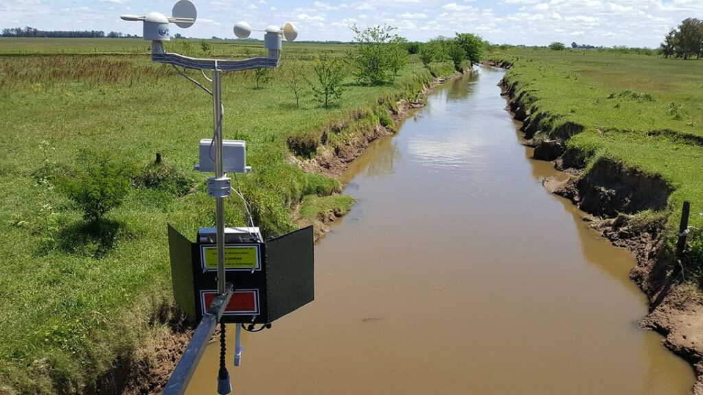
This system is built on proven technology: ultrasonic or pressure-based water level sensors, wireless transmission units, solar power, automatic sirens, and a digital platform that displays real-time data and issues mobile or radio alerts. Each unit covers up to 3 km downstream, with configurable alert thresholds. The “transformed volume” is not treated water—it’s risk avoided: communities that once lost homes, livestock, and schools now gain time to act. In regions where a flash flood can carry over 120,000 m³ of water per hour, a 15-minute advance warning can save everything.
Immediate benefits include reduced human and material losses, activated local response networks, and stronger coordination between communities and civil protection authorities. Medium-term, the system strengthens water governance, empowers women and youth in alert brigades, and decreases collective anxiety during the rainy season. Long-term, it forms part of a resilient watershed model—with historical data, adaptive learning, and climate-aware protocols.
The current challenge is clear: there is no monitoring, no alert mechanism, and no defined evacuation routes. The root causes are multifaceted: complex geography, limited public investment, and a disconnect between national systems and local realities. Climate change only magnifies the problem: past hydrology no longer predicts future events. This system addresses those challenges with precision: it is energy-autonomous, internet-independent, community-centered, and externally verifiable.
This is the kind of solution that visionary companies—those truly committed to ESG—should lead. It offers not just reputational benefits, but tangible social license to operate, strategic partnerships, and global visibility. Supporting this project is not charity—it’s climate-smart responsibility. It’s an opportunity to lead boldly, contribute to adaptation, and be part of a growing global network of communities and companies that refuse to wait for the next disaster.
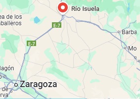
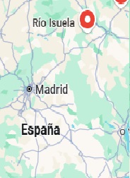
The project integrates cutting-edge technology, sustainable water management, and community engagement to develop a comprehensive flood risk mitigation strategy for the Isuela River Basin. Through early warning systems, nature-based solutions, and capacity building, the initiative aims to enhance flood resilience, reduce water-related damages, and improve emergency preparedness.
1. Early Warning System and Real-Time Monitoring
To enable proactive flood risk management, the project will deploy IoT-enabled water level and flow sensors at critical locations throughout the Isuela River Basin. These sensors will provide real-time data on hydrological conditions, allowing authorities to detect rising water levels early. The collected data will be integrated with hydrometeorological prediction models, enhancing flood forecasting accuracy by combining sensor inputs with weather forecasts.
The system will also feature automated data transmission to emergency response platforms, ensuring that local authorities and disaster management teams receive instant alerts. This will allow for faster decision-making, efficient resource allocation, and timely evacuations, ultimately reducing the impact of floods on vulnerable communities.
2. Sustainable Water Management and Nature-Based Solutions
Beyond technological interventions, the project will implement nature-based solutions to enhance the basin’s natural capacity to absorb and manage floodwaters. Buffer zones and natural retention areas will be established to reduce surface runoff and increase infiltration, preventing excessive water from overwhelming river channels. Additionally, constructed wetlands and absorption zones will be developed to improve water filtration and reduce sediment transport, minimizing riverbed degradation.
To further strengthen flood mitigation efforts, the project will focus on reforestation and riparian restoration along riverbanks. This will help stabilize the soil, prevent erosion, and regulate water flow, reducing the likelihood of severe flooding during heavy rainfall events.
3. Capacity Building and Stakeholder Engagement
For long-term success, the project will actively involve local authorities, emergency responders, and community members in flood risk management. Training programs will equip key stakeholders with the skills to interpret real-time flood data, implement response protocols, and coordinate emergency measures effectively.
Additionally, public awareness campaigns will educate local residents on early warning alerts, flood preparedness, and community-based response strategies. By improving public understanding and preparedness, the project will help reduce human and economic losses during flood events.
SDG 6 – Clean Water and Sanitation: Enhances water management by providing real-time data on river flow levels, reducing flood-related water losses, and optimizing resource allocation.
SDG 11 – Sustainable Cities and Communities: Strengthens climate resilience by integrating nature-based flood mitigation strategies and improving urban planning through real-time monitoring.
SDG 13 – Climate Action: Serves as a key adaptation strategy to mitigate climate change effects, enabling proactive responses to extreme weather events and reducing their socioeconomic impact.
SDG 17 – Partnerships for the Goals: Engages local authorities, emergency response agencies, academic institutions, and international sustainability networks to ensure collaborative and data-driven disaster management.
The project will be carried out through a structured, ensuring efficiency, effectiveness, and long-term sustainability. Each phase has been carefully designed to optimize flood risk management through a combination of advanced technology, real-time monitoring, and stakeholder collaboration.
1. Comprehensive Diagnostic Study
The first phase focuses on conducting a detailed hydrological assessment to understand the historical and current flood risks in the Isuela River Basin. This diagnostic study will analyze historical flood patterns, identifying areas that are most vulnerable to extreme weather events. High-risk zones will be mapped using hydrological and topographical data, allowing for a clear understanding of flood-prone regions.
In addition to hydrological assessments, this phase will also involve stakeholder identification and engagement. Local governments, emergency response teams, and affected communities will be consulted to ensure their active participation in the project. Workshops and consultations will be conducted to gather insights from those directly impacted by flooding, fostering collaboration and commitment. By ensuring early engagement, the project will benefit from local knowledge and promote community-driven solutions.
2. Design and Technological Integration
Once the diagnostic phase is complete, the project will transition into the design and technology integration phase, focusing on the installation of IoT-based water level sensors at key monitoring points along the Isuela River Basin. These sensors will provide real-time data on water levels, significantly improving flood forecasting and early warning capabilities.
The system will be integrated with open-data platforms and advanced hydrological forecasting models, allowing for more accurate flood risk assessments. Machine learning algorithms will be utilized to enhance the predictive capabilities of the system, ensuring that alerts are issued with greater precision and lead time.
To further enhance flood response efficiency, automated alert thresholds will be established. When water levels reach predefined risk levels, notifications will be sent directly to emergency response teams, local authorities, and community members, enabling faster decision-making and response coordination.
3. System Deployment and Calibration
With the technology designed and integrated, the next phase will focus on the physical deployment of the monitoring system and calibration of the sensors. The water level sensors will be strategically installed at key hydrological monitoring sites, ensuring comprehensive coverage of flood-prone areas. Rigorous testing and calibration procedures will be carried out to ensure that all sensors provide accurate and reliable data under different weather conditions.
During this phase, capacity-building programs will be conducted to train local emergency response teams, municipal authorities, and community leaders on how to interpret the sensor data, operate the system, and respond to alerts. Technical training workshops will be organized to ensure that local actors are equipped with the necessary skills to maintain and troubleshoot the monitoring system, ensuring its long-term functionality.
4. Impact Measurement and Adaptive Management
Once the system is fully operational, the project will implement a comprehensive impact measurement and adaptive management framework. The effectiveness of the flood early warning system will be evaluated based on several key indicators, including the number of early warnings issued, the reduction in infrastructure damage, and the overall improvement in emergency response times.
The system will continuously be refined based on real-time data analysis, allowing for adaptive improvements in flood forecasting accuracy. Lessons learned from each flood event will be incorporated into hydrological models, ensuring that the system evolves and improves over time. Additionally, stakeholder feedback loops will be established, allowing local communities to provide insights on system performance and suggest enhancements.
The Early Warning System for Flood Prevention in the Isuela River Basin represents a pioneering approach to flood risk management, leveraging technology and sustainable water management practices to build climate resilience in vulnerable communities. By integrating real-time hydrological monitoring with predictive flood analytics, the project will provide an effective, data-driven solution for disaster prevention. The initiative is designed not only to mitigate the immediate risks associated with flooding but also to enhance long-term water resource governance and environmental conservation.
A crucial aspect of this project is its commitment to stakeholder collaboration and institutional capacity-building. By actively involving local governments, emergency response teams, academic institutions, and community organizations, the project will foster a multi-sectoral approach to flood mitigation, ensuring that its benefits extend beyond immediate disaster response. This engagement will also facilitate the institutionalization of early warning protocols, integrating them into broader regional and national water governance frameworks.
From an environmental perspective, the project will contribute significantly to watershed conservation and climate adaptation. By reducing flood intensity and frequency, it will minimize erosion, sediment transport, and the degradation of aquatic ecosystems. The promotion of nature-based flood management solutions, such as reforestation of riparian zones and restoration of floodplain wetlands, will enhance the basin’s ability to absorb excess water naturally, reinforcing the resilience of both human and ecological systems.
Ultimately, this initiative sets a scalable and replicable model for climate resilience and disaster risk reduction. As climate change continues to intensify extreme weather events, projects like this will become increasingly vital for protecting communities, securing water resources, and safeguarding natural ecosystems. The Isuela River Basin will serve as a leading example of proactive flood risk management, demonstrating how technological innovation, environmental sustainability, and community engagement can work together to build a safer and more resilient future.
The project will be carried out through a structured, multi-phase process designed to ensure efficiency and effectiveness.
The first phase will involve a comprehensive diagnostic study to assess historical flood patterns, high-risk areas, and existing hydrological conditions. This assessment will also identify key stakeholders, including local governments, emergency response teams, and affected communities, ensuring collaboration and commitment from all relevant parties.
Following this, the project will move into the design and technological integration phase, where IoT-based water level sensors will be installed at key monitoring points. These devices will be integrated with open-data platforms and hydrological forecasting models, allowing for real-time flood risk assessment and improved prediction accuracy. Alert thresholds will be established to automate notifications and improve response times.
The third phase will focus on system deployment and calibration, ensuring that monitoring devices function optimally. Local actors will receive technical training on how to operate and maintain the system, while the sensors will undergo rigorous testing and calibration for precise data collection.
Finally, the project will implement an impact measurement and adaptive management framework, evaluating flood risk reduction through early warnings issued, infrastructure damage prevented, and continuous refinement of hydrological models based on real-time data.
By combining advanced technology, sustainable water management, and community engagement, this initiative will establish a scalable and replicable model for flood risk reduction, ensuring long-term climate resilience and water security for the Isuela River Basin.